Hold on While Loading Virtual Maps and routing ride # LAWM-T2
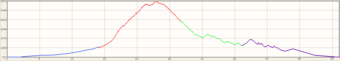
Total elevation gain (accumulative going up hill): 4,631 feet
List all route maps
LAWM-T2 :
to rest stop-1
to rest stop-2
to rest stop-3 (Lunch)
back
Accum. elevation gain: 4,631 feet
Post a Comment for ride #LAWM-T2; Level 4; 49.8 miles
Name/Nick:
From:
Email:
(not visible)
Remember me
Your Comment / Story / Advice:
(no HTML)
Tagged (03/31/07): Phill
Upload Images from this ride
Image:
Image:
Image:
Image:
Image:
Upload more
Image:
Image:
Image:
Image:
Image:
Upload more
Image:
Image:
Image:
Image:
Image:
Upload more
Image:
Image:
Image:
Image:
Image:
Upload more
Image:
Image:
Image:
Image:
Image: